
Real-Time Asset Tracking (RTLS): A Complete Guide to Indoor Location Tracking
How much time does your team lose every week just looking for things? A missing forklift, a misplaced tool, a piece of equipment that should be in bay three but is nowhere to be found. In busy facilities, these small searches add up to enormous wasted time and cost — and the frustrating part is that the asset is usually somewhere on site, just not where anyone expected.
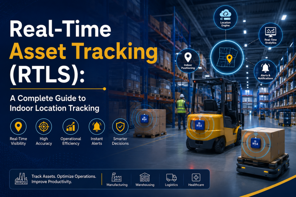
Real-time location systems, or RTLS, solve this problem by showing you exactly where your assets are, live, on a map of your facility. Instead of scanning items at fixed points, RTLS continuously tracks their position indoors. This complete guide explains what RTLS is, how it works, the technologies behind it, its benefits and applications, and how to choose and implement the right solution.
▶ Watch: RTLS Asset Tracking
Table of Contents
- What is RTLS?
- How does RTLS work?
- RTLS technologies compared
- RTLS vs traditional tracking
- Key components
- Benefits of RTLS
- Applications by industry
- How to choose an RTLS
- Implementation and best practices
- Challenges and the future
- FAQs and conclusion
What Is RTLS (Real-Time Location System)?
A real-time location system (RTLS) is a combination of hardware and software that automatically identifies and tracks the location of assets or people, in real time, within a defined area such as a building or campus. Rather than telling you where something was when it was last scanned, an RTLS tells you where it is right now.
The idea is simple: attach a small tag to each asset, install fixed reference points around the facility, and let software calculate and display each tag’s live position. The result is a continuously updated map of where everything is — the foundation of true indoor location tracking and modern asset visibility.
How Does an RTLS Work?
Every RTLS follows the same basic principle, whatever technology it uses. Tags on assets communicate with fixed anchors or readers placed around the facility. A location engine uses those signals to calculate each tag’s position, and RTLS software turns that into a live view you can act on.
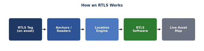
Here is what happens at each stage. The RTLS tag on an asset regularly transmits a signal. Fixed anchors or readers detect that signal from several points. The location engine then works out the tag’s position — using methods such as the time it takes signals to arrive, or their angle — to pinpoint where the asset is. Finally, the RTLS software plots that real-time location data on a floor plan and feeds it to the systems and people who need it. Because this happens constantly, you always see current positions, not a snapshot from the last manual count.
RTLS Technologies Compared
RTLS is not a single technology but a family of them. The main options trade off accuracy, cost, and battery life differently, so the right choice depends on how precisely you need to locate assets and your budget.
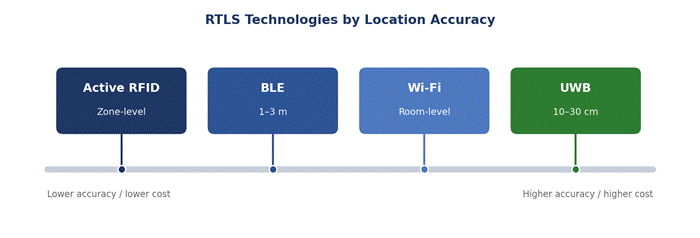
The main RTLS technologies are ultra-wideband (UWB), Bluetooth Low Energy (BLE), Wi-Fi, and active RFID:
| Technology | Accuracy | Battery life | Best for |
| UWB | 10–30 cm | Moderate | High-precision, high-value asset tracking |
| BLE | 1–3 m | Long | Cost-effective, large-scale indoor tracking |
| Wi-Fi | Room-level | Depends on device | Using existing Wi-Fi infrastructure |
| Active RFID | Zone-level | Long | Simple zone presence and low cost |
UWB offers the highest location accuracy — down to a few centimetres — making it ideal for high-value assets, though at a higher cost. BLE is the popular, cost-effective middle ground, with good accuracy and long battery life for large-scale indoor tracking. Wi-Fi can reuse existing infrastructure for room-level tracking, while active RFID tags provide simple, low-cost zone-level presence. Many real-world deployments blend more than one to balance cost and precision.
Ultra-Wideband (UWB)
UWB is the precision leader, using very short radio pulses to locate tags to within 10–30 centimetres. That accuracy makes it ideal for tracking high-value assets, guiding automated equipment, or any application where knowing the exact position matters. The trade-off is a higher cost per tag and anchor, so UWB is usually reserved for the areas and assets that truly need centimetre-level precision.
Bluetooth Low Energy (BLE)
BLE has become the most popular RTLS technology for good reason. Its tags are inexpensive and enjoy long battery life, and because Bluetooth is everywhere, the supporting hardware is affordable. BLE typically locates assets to within one to three metres — accurate enough for most indoor asset tracking — which makes it the natural choice for large-scale, cost-effective deployments.
Wi-Fi
Wi-Fi-based RTLS reuses the wireless network many facilities already run, tracking tags or devices to room-level accuracy. Because the infrastructure often already exists, it can be a quick, low-cost way to add basic location awareness, though its accuracy is coarser than UWB or BLE.
Active RFID
Active RFID tags carry their own battery and broadcast to fixed readers, providing simple zone-level presence — knowing which area an asset is in rather than its exact coordinates. It is a robust, low-cost option where zone-level visibility is all you need.
RTLS Location Accuracy Levels
Not every use case needs pinpoint accuracy, and matching the level to your need keeps costs sensible. RTLS accuracy is often described in four broad levels:
- Presence: knowing an asset is somewhere within the facility or has entered or left it.
- Zone-level: knowing which area or zone an asset is in, such as a department or aisle.
- Room-level: pinpointing the specific room or bay an asset occupies.
- Sub-room (precise): locating an asset to within a metre or even centimetres inside a space.
A tool crib might only need zone-level tracking, while guiding a robot or finding a specific instrument on a bench demands sub-room precision. Deciding the level you need is the single most important step in specifying an RTLS, because it drives both the technology choice and the cost.
RTLS vs Traditional Tracking
It helps to be clear about how RTLS differs from the barcode or manual methods most facilities start with. Traditional tracking captures a location only at the moment an item is scanned; between scans, you are guessing. RTLS removes the guesswork with continuous, automatic updates.
| Aspect | RTLS | Traditional (barcode / manual) |
| Location data | Continuous, real-time | Point-in-time, when scanned |
| Effort | Automatic | Manual scanning or counts |
| Visibility | Always current | Out of date quickly |
| Best for | Finding and monitoring assets live | Recording items at checkpoints |
This does not make barcodes obsolete — they remain excellent for low-cost identification at checkpoints. RTLS simply answers a different question: not “what passed here?” but “where is it right now?”
RTLS vs GPS: Why Indoors Is Different
People often ask why they cannot just use GPS. The answer is that GPS depends on signals from satellites, which struggle to penetrate roofs and walls, making it unreliable and imprecise indoors. RTLS is purpose-built for exactly the environments where GPS fails — inside warehouses, factories, and hospitals — using local anchors instead of satellites.
In practice the two are complementary. GPS handles the open outdoors and long-haul transport, while RTLS takes over the moment assets move inside a facility. Operations that need both indoor and outdoor visibility often combine RTLS with GPS or LoRaWAN for seamless end-to-end coverage.
Key Components of an RTLS
Whatever technology you choose, an RTLS is built from four essential parts working together:
- RTLS tags: the small devices attached to assets or worn by people, which transmit signals.
- Anchors or readers: the fixed reference points around the facility that detect tag signals.
- Location engine: the software that calculates each tag’s position from those signals.
- RTLS software: the application that displays live locations, sets alerts, and integrates with other systems.
The tags and anchors capture the raw signals; the location engine and software turn them into the real-time asset map that people actually use.
The Benefits of RTLS
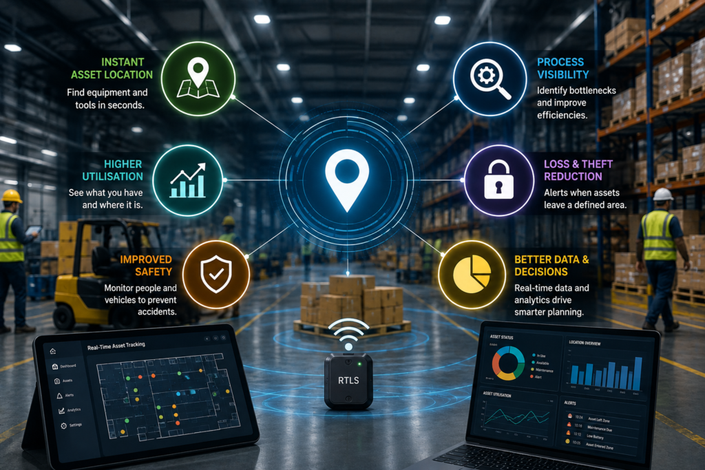
The value of real-time location goes far beyond simply finding lost items. A well-deployed RTLS improves almost every part of an operation:
Applications by Industry
RTLS has found a home wherever assets, equipment, or people need to be located quickly and reliably indoors:
| Industry | How RTLS is used |
| Manufacturing | Tracking WIP, tools, and forklifts on the floor |
| Warehousing & logistics | Locating stock, equipment, and returnable assets |
| Healthcare | Finding medical equipment, staff, and patients |
| Automotive | Tracking parts and vehicles through the plant |
| Aerospace | Locating high-value tools and components |
Across all of these, RTLS complements broader asset tracking and warehouse systems, adding the live, indoor location layer that barcodes and periodic counts cannot provide.
RTLS in Manufacturing
On the factory floor, RTLS gives supervisors a live view of work-in-progress, tools, and mobile equipment. Knowing exactly where a part or fixture is prevents line stoppages caused by hunting for materials, and tracking forklifts and people supports both safety and efficiency. Tied into a manufacturing execution system, that location data helps balance the line and cut downtime.
RTLS in Warehousing and Logistics
In the warehouse, RTLS locates stock, forklifts, and returnable transport items in real time, so nothing is lost and every asset is used well. It reveals congestion in the aisles, confirms where goods are staged, and — combined with a WMS — helps direct work to the nearest resource. The result is faster movement, better space use, and fewer costly searches.
How to Choose the Right RTLS
There is no single RTLS that suits every facility, so start from your requirements rather than the technology. Work through these questions before committing:
- What do you need to track — assets, people, vehicles, or all three?
- How precise must the location be — zone-level, room-level, or centimetre-level?
- How large is the area, and is it indoor, outdoor, or both?
- What tag battery life and maintenance can you support?
- What is your budget, and can you reuse existing infrastructure such as Wi-Fi?
Your answers point naturally to a technology: UWB for high precision, BLE for cost-effective scale, Wi-Fi to reuse infrastructure, or active RFID for simple zone tracking. The most cost-effective solution is the one that meets your accuracy needs without over-engineering.
RTLS Cost and ROI Factors
The cost of an RTLS depends mainly on the technology, the number of tags and anchors, and the size of the area to cover. UWB costs more per point than BLE or active RFID, and denser anchor coverage raises the price but improves accuracy. Software, integration, and ongoing tag maintenance also form part of the total.
The return comes from the time saved finding assets, higher equipment utilisation, reduced loss and theft, and the efficiency gains that flow from live visibility. For many facilities, the hours reclaimed from searching alone justify the investment, with safety and utilisation benefits on top. As with any technology project, modelling the expected return against your own numbers is the surest way to build the case.
Implementation and Best Practices
A successful RTLS rollout follows a disciplined path. Begin by defining the specific problem you want to solve and the accuracy you genuinely need — over-specifying is a common and expensive mistake. Run a pilot in one area of your real facility, because walls, metal, and layout all affect performance in ways a brochure cannot predict.
From there, plan anchor placement carefully for full coverage, choose tags suited to your assets and environment, and integrate the RTLS with your existing software — a warehouse management system, ERP, or maintenance platform — so the location data drives real workflows. Finally, train your team and scale gradually, expanding zone by zone once each area is proven.
Integrating RTLS with WMS, MES and ERP
RTLS delivers its full value when its location data flows into the systems that run the operation. Feeding real-time positions into a WMS helps direct picking and put-away to the nearest resource. Linking it to a manufacturing execution system ties asset location to production status, and connecting it to an ERP or maintenance platform lets location trigger business processes — for example, flagging when a serviceable asset is due for maintenance. The location engine becomes not just a map, but a live input to the wider enterprise.
Security, Privacy and Data Governance
Because RTLS can track people as well as assets, it should be deployed thoughtfully. Clear policies on what is tracked, who can see it, and how long data is kept build trust with staff and meet regulatory expectations. Securing the location data itself — in transit and at rest — protects sensitive information about your operation. Handled openly and responsibly, RTLS improves safety and efficiency without compromising privacy.
Challenges to Plan For
RTLS is powerful, but a few realities need managing. Signal accuracy can be affected by metal, walls, and dense racking, so real-world testing matters. Battery-powered tags need a maintenance plan for replacement. And, as with any system, the up-front investment in tags, anchors, and software must be justified by the value of the visibility it provides. None of these is a barrier — they are simply factors to plan around, ideally with an experienced partner.
The Future of RTLS
RTLS is becoming a core layer of the connected, data-driven facility. As Industrial IoT and AI mature, real-time location data increasingly feeds predictive analytics, automated workflows, and digital twins that model the facility virtually. UWB is making centimetre-level accuracy more affordable, and hybrid systems that blend technologies are becoming the norm. The direction of travel is clear: from simply finding assets to using their movement as live intelligence for the whole operation.
Conclusion
Real-time location systems turn one of the most persistent operational headaches — not knowing where things are — into a solved problem. By continuously tracking assets and people indoors, RTLS saves time, improves safety and utilisation, and provides the live data that smarter operations depend on.
The best RTLS is the one matched to your accuracy needs, environment, and budget — often a blend of technologies like UWB, BLE, Wi-Fi, and active RFID. Start by defining what you need to see, pilot it in your real facility, and build from there toward complete, real-time asset visibility.
Get Real-Time Asset Visibility with Brilliant Info Systems
Brilliant Info Systems designs and integrates RTLS and RFID asset-tracking solutions — spanning UWB, BLE, Wi-Fi, and active RFID — connected to your warehouse management and wider systems. Talk to our team and we will help you design the right indoor location tracking solution for your facility.
Frequently Asked Questions
What is RTLS in simple terms?
RTLS, or a real-time location system, is technology that continuously tracks where assets or people are inside a facility and shows their live position on a map — unlike barcodes, which only record a location when scanned.
How accurate is RTLS?
Accuracy depends on the technology. UWB can locate assets to within 10–30 cm, BLE to 1–3 metres, Wi-Fi to room-level, and active RFID to zone-level. You choose based on how precise you need to be.
What is the difference between RTLS and RFID?
Standard RFID identifies items at fixed checkpoints, while RTLS continuously tracks an asset’s live location across an area. Active RFID is actually one of the technologies that can power an RTLS for zone-level tracking.
Which RTLS technology is best?
There is no single best option. UWB is best for high precision, BLE for cost-effective large-scale tracking, Wi-Fi for reusing existing infrastructure, and active RFID for simple zone presence. The right choice depends on your needs.
Can RTLS work outdoors?
RTLS is designed mainly for indoor location tracking, where GPS is unreliable. For wide outdoor areas, technologies like GPS or LoRaWAN are often combined with RTLS for full coverage.
Does RTLS integrate with my existing systems?
Yes. A good RTLS integrates with your WMS, ERP, or maintenance software, so live location data drives real workflows rather than sitting in a separate application.