
How GPS And Blast Monitoring can work Together in smart mining operations
Modern mines run on data. Every drill pattern, haul route, and blast is now planned, tracked, and reviewed with digital tools that were unheard of a decade ago. Two of the most important technologies in this shift are GPS positioning and blast monitoring. On their own, each solves a specific problem. Used together, they give mining teams a single, real time picture of where work is happening and how the ground is responding to every shot.
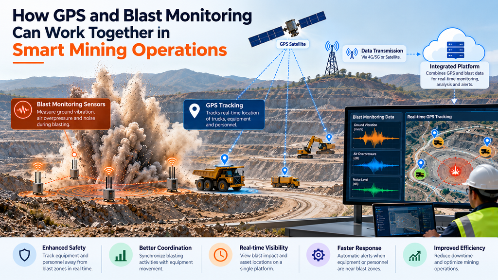
This guide explains how GPS and blast monitoring can work together in smart mining operations — how the two systems connect, what that combination delivers, and why it matters for enhancing safety and operational efficiency across the site.
▶ Watch: Brilliant Info Systems on YouTube
Two Technologies, One Goal
GPS gives a mine precise location and timing. It tells crews exactly where a sensor, drill, or vehicle sits on the pit, and it supplies the accurate time reference that ties separate readings into one synchronized record.
Blast monitoring measures what a shot does to the surrounding ground and air. Seismographs and geophones capture ground vibration (peak particle velocity) and air overpressure, the two forces that can damage nearby structures. For a deeper look at each force, see our guides on ground vibration monitoring and air overpressure monitoring.
Separately, these are useful. Combined, they answer a sharper question: not just how strong a blast was, but exactly where it happened, when, and how its energy travelled. That context is the foundation of smart, data-driven blasting.
How the Two Systems Connect
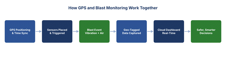
In practice, the workflow links GPS and blast monitoring systems at several points:
- Accurate sensor placement: GPS records the exact coordinates of every monitoring unit, so each vibration and air reading is tied to a known distance from the blast.
- Time synchronization: GPS timing aligns readings from multiple sensors to the millisecond, letting engineers see how a wave propagates across the site.
- Geo-tagged results: Each blast record carries its location, making it easy to map results against the mine plan and spot patterns over time.
- Live dashboards: Cloud platforms plot every reading on a site map in real time, so supervisors see both the number and the place at a glance.
The result is a connected chain from field to decision. To see how that data actually reaches the control room, read from sensor to dashboard.
What the Combination Delivers
Bringing GPS and blast monitoring together changes how a mine manages risk and performance. A quick summary of the main gains:
| Benefit | What It Means on Site |
| Enhancing safety | Location-aware alerts warn teams the moment a reading near a sensitive structure climbs too high. |
| Operational efficiency | Geo-tagged data helps refine blast design, improving fragmentation without raising charge weight. |
| Reducing downtime | Remote, real time readings mean fewer manual site visits and faster clearance to resume work. |
| Environmental impact | Precise control of vibration and air overpressure keeps blasts within limits and protects neighbours. |
| Compliance records | Every shot is logged with location, time, and result — a defensible audit trail for regulators. |
Enhancing Safety and Reducing Downtime
The safety case is the clearest. When a blast fires, state of the art monitoring systems capture the vibration and air response instantly, and GPS fixes the exact point each reading came from. If a value approaches a safe threshold near homes or infrastructure, the platform can send an automatic alert to the right people — a core part of why real-time blast monitoring is critical for modern operations.
That speed also cuts lost time. Instead of waiting for a technician to drive out, download a unit, and review the data, supervisors see results on a dashboard within seconds. Teams can clear an area and restart work sooner, directly reducing downtime. The same remote visibility supports multi-site blast monitoring, where one control room oversees several pits at once.
Smarter Blasting and Better Decisions
Over many blasts, the combined dataset becomes a planning tool. Because each record of vibration and air overpressure is tied to a precise location and charge configuration, engineers can see which patterns produce the best fragmentation with the least ground disturbance. GPS-referenced IoT sensors and asset tracking extend this visibility to drills and vehicles, so the whole operation is mapped, not just the shot.
This is where mining becomes genuinely “smart”: every decision is backed by location-stamped evidence rather than estimates. It is also how IoT is changing blast and environmental monitoring across the industry, and why automated alerts help teams respond faster to abnormal conditions.
Conclusion
GPS and blast monitoring were built to solve different problems, but together they give smart mining operations something neither delivers alone: a precise, real time view of every blast and exactly where its energy went. That combination supports enhancing safety, reducing downtime, lowering environmental impact, and improving operational efficiency — the goals every modern mine is working toward.
Brilliant Info Systems builds connected monitoring systems that bring these technologies together for mining teams. Explore our blast vibration monitoring solution or talk to our team to design a setup around your site.
Frequently Asked Questions
Why is GPS used in blast monitoring?
GPS provides two things monitoring needs: the exact location of each sensor and an accurate time reference. Together these let engineers tie every vibration and air reading to a known point and align readings from multiple units, so they can see how a blast wave travels across the site.
Does combining GPS and blast monitoring improve safety?
Yes. Location-aware, real time readings let the system flag the moment a value near a sensitive structure climbs too high, so teams can act immediately. This is central to enhancing safety and keeping blasts within regulatory limits.
How does this reduce downtime?
Remote dashboards show blast results within seconds, so crews no longer wait for manual data retrieval before clearing an area. Faster clearance means work resumes sooner, improving operational efficiency.
Is this only for large mines?
No. Even single-site operations benefit from geo-tagged, synchronized records. Cloud monitoring systems scale from one pit to many, so smaller mines gain the same accuracy and compliance trail as large ones.